This comment period has closed
Save Our Sky Blue Waters submitted comments with Save Lake Superior Association, the Center For Biological Diversity, Friends of the Cloquet Valley State Forest and the Sierra Club on the PolyMet NorthMet project.
Click here for a PDF of our comments
*****
NorthMet Supplemental Draft Environmental Impact Statement (SDEIS) Release
State and federal environmental review of the proposed PolyMet Mining Inc. projectA comprehensive environmental analysis of Minnesota’s first proposed copper-nickel mine has been released for public review and input. The Minnesota Department of Natural Resources, U.S. Army Corps of Engineers, and U.S. Forest Service are seeking public review and input on the SDEIS. |
Take Action! – Comment by March 13, 2014 on the PolyMet Mine and Land Exchange!
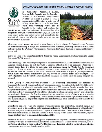
Will Corporate Profits Be Put Above the People, Land, Water and Wildlife of the Arrowhead?
Harmful to the Superior National Forest and LAKE SUPERIOR Watershed
Minnesota's Arrowhead Region Under Threat
ACTION ALERT!
Bad Deal for Minnesota, Good Deal for PolyMet
PolyMet's SDEIS confirms our concerns about sulfide mining in northeast Minnesota
Let the agencies know that you oppose the PolyMet Mine and Land Exchange!
Land Exchange - The PolyMet project proposes a land exchange of 6,700 acres of federal land within the Superior National Forest.
The Forest Service is under no obligation to do a land exchange with PolyMet. According to current federal law, it is illegal to strip mine land acquired under the Weeks Act for watershed protection.
Ask for an extension of the public comment period for the proposed PolyMet Mine
Currently there is a 90 day comment period but due to the size, complexity and difficulty in reviewing the SDEIS - 180 days is needed to adequately review the proposal. The draft EIS was already found to be lacking in several areas and received a scathing EPA review. 90 additional days of review is little to ask in light of the potential for long term problems and the dismal record of sulfide mining around the world, regardless of what mine operators promised.
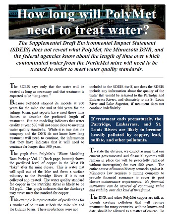
• Treatment of contaminated water will be required for more than 500 years. The modeling done by PolyMet stopped at year 200
(at the mine site) and year 500 (at the plant site) because that was the point at which it became clear that water quality would
not get worse. However, the modeled water quality at 500 years does not come close to meeting water quality standards.
• No back-up plan if Reverse Osmosis doesn't work for water treatment.
• Hardrock mining carries the potential for asbestos-like minerals to be released
in water effluent or air emissions. The PolyMet environmental review process does not
adequately address their effects on human health as this is already
an emerging concern in northern Minnesota.
• Destruction of Wetlands - The SDEIS predicts that 912 acres of wetlands will be destroyed by filling or
excavation and up to 7,413 acres may be “indirectly” impacted, mostly by converting wetlands to dry
land. “Mitigation” for the direct impacts will occur primarily outside of the St. Louis River/Lake
Superior watershed, in an area to the south that is unlikely to support comparable ecosystems and cannot
replace the lost functions to the St. Louis River system
• The proposed mine is harmful to wildlife, threatening home ranges of endangered lynx, wolf, as well as moose
which are dramatically declining in the state.
How to comment on the SDEIS
Comments
Comments will be accepted until 4:30 PM CT on Thursday, March 13, 2014.
Email: NorthMetSDEIS.dnr@state.mn.us
Submit comments to: NorthMetSDEIS.dnr@state.mn.us. E-mail submissions should include a full name and legal mailing address.
Mail:
Written comments may also be submitted to:
Lisa Fay, EIS Project Manager
MDNR Division of Ecological and Water Resources
Environmental Review Unit
500 Lafayette Road, Box 25
St. Paul, MN 55155-4025
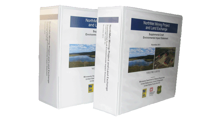
NorthMet SDEIS PolyMet Mining Inc. Project
Supplemental Draft Environmental Impact Statement (SDEIS)
Note: this PDF is large (136 MB, 2,169 pages) and could take time to download.
Download Individual Chapters
The following documents are in ![]() format.
format.
Table of contents
- Cover
- Signature Page
- EIS Front Matter
- Executive Summary
- Chapter 1 - Introduction
- Chapter 2 - EIS Development
- Chapter 3 - Proposed Action and Alternatives
- Chapter 4 - Affected Environment
- Chapter 5 - Environmental Consequences
- Chapter 6 - Cumulative Effects
- Chapter 7 - Comparison of Alternatives and Other NEPA Considerations
- Chapter 8 - Major Differences of Opinion
- End Matter
- Appendix A - Thematic Responses to DEIS Comments
- Appendix B - Underground Mining Alternative Position Paper
- Appendix C - Tribal Position Supporting Information
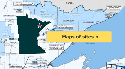
Map of sites found HERE
Media on PolyMet Project
PolyMet Fact Sheets
How long will PolyMet need to treat water? and Issues for Commenting on PolyMet's EIS and Sierra Club PolyMet Fact Sheet
PolyMet project Tribal Cooperating Agency Fact Sheets
Information prepared by staff from the tribal cooperating agencies and supporting intertribal agencies: Fond du Lac Band of Lake Superior Chippewa, Grand Portage Band of Lake Superior Chippewa, Bois Forte Band of Lake Superior Chippewa, Great Lakes Indian Fish & Wildlife Commission and the 1854 Treaty Authority.
Wetlands Mitigation and Destruction
 It's time to put PolyMet on the shelf - By Elanne Palcich
What's Wrong With PolyMet's Mine?
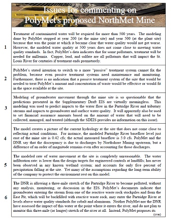
Suggested Issues for commenting on the proposed NorthMet Mine
· Treatment of contaminated water will be required for more than 500 years. The modeling done by PolyMet stopped at year 200 (at the mine site) and year 500 (at the plant site) because that was the point at which it became clear that water quality would not get worse. However, the modeled water quality at 500 years does not come close to meeting water quality standards. In fact, PolyMet’s data indicates that for some pollutants, treatment will be needed for millennia. Copper, lead, and sulfate are all pollutants that will impact the St. Louis River for centuries if treatment ends prematurely.
PolyMet’s stated intention to switch to a more “passive” treatment system cannot fix the problem, because even passive treatment systems need maintenance and monitoring. Furthermore, there is no indication that a passive treatment system of the size that would be needed to treat PolyMet’s amount and concentration of waste would be effective or would fit in the space available at the site.
· Modeling of groundwater movement through the mine site is so questionable that the predictions presented in the Supplementary Draft EIS are virtually meaningless. This modeling was used to predict impacts to the water flow in the Partridge River and tributary streams and impacts to groundwater and surface water quality. It will apparently also be used to set financial assurance amounts based on the amount of water that will need to be collected, managed, and treated (although the SDEIS provides no information on this issue).
The model creates a picture of the current hydrology at the site that does not come close to reflecting actual conditions. For instance, the modeled Partridge River baseflow level just east of the mine site is 0.42 cfs; the actual measured baseflow is 5.0 cfs. PolyMet and the DNR say that the discrepancy is due to discharges by Northshore Mining upstream, but a difference of an order of magnitude remains even after accounting for those discharges.
The modeled rate of water movement at the site is completely unreasonable. The water infiltration rate: is lower than the design targets for engineered controls at landfills; has never been observed in any known wetland system; and accounts for only five percent of precipitation falling at the site. Yet many of the assumptions regarding the long-term ability of the company to protect the environment rest on this model.
· The DNR is allowing a three-mile stretch of the Partridge River to become polluted, without any analysis, monitoring, or discussion in the EIS. PolyMet’s documents indicate that groundwater entering the stream from one of the reactive waste rock stockpiles and from the East Pit, which will be backfilled with reactive waste rock, may enter the Partridge River at levels above water quality standards for cobalt and aluminum. Neither PolyMet nor the DNR have assessed the impact of this water at the point where it enters the river, and do not plan to monitor this three-mile (or longer) stretch of the river at all. Instead, PolyMet proposes its first monitoring point at a location below the point where the influx of clean water from its treatment plant will mask any water quality violations that might occur upstream.
· PolyMet’s humidity cell testing indicates that its waste rock leaches mercury at more than four times the water quality standard. Despite (or perhaps because of) the fact that the release of mercury is the single most sensitive issue for any new facility located in the Lake Superior Basin, PolyMet proposes not to conduct an analysis of the amount of mercury that will enter the Partridge River from leakage from waste rock stockpiles and mine pits. Yet it has done this analysis for each of 28 other constituents, many of which have nowhere near the potential for impacts that mercury does, and a few of which can be expected to act similarly to mercury in movement through groundwater. PolyMet attempts to excuse this discrepancy by stating that “insufficient data and a general lack of definitive understanding of mercury dynamics prevented modeling mercury like the other solutes.” This appears to be a bald attempt to avoid federal and state regulations that do not allow any new source of mercury discharge within the Lake Superior Basin.
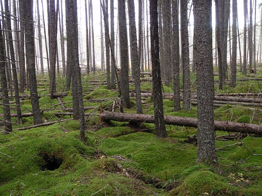
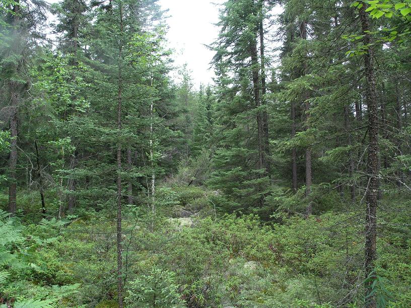
· The NorthMet Mine would completely destroy at least 1,741 acres of high quality ecosystems, which provide habitat for many wildlife species, including Canada lynx, wolves, and moose. Many more acres are likely to be degraded in the area surrounding the mine. Losses will include 1,741 acres of Minnesota Biological Survey sites of High Biodiversity Signficiance; 698 acres of Jack pine/black spruce forest, which are considered imperiled/vulnerable in Minnesota; 912 acres of high quality wetlands; and portions of one of only twelve known populations of floating marsh marigold in the state. All of these resources are currently located within the Superior National Forest. Why are we categorizing areas of high biodiversity, imperiled ecosystems, and endangered plants if we are not going to protect them, even when they occur on public land?
· Mines and other development in the Mesabi Iron Range currently create a significant barrier to wildlife migration; studies have found only 18 narrow corridors within the Range that allow wildlife to move from north to south of the Range. Planned projects and expansions within the taconite industry will severely limit or destroy many of these corridors in the next few years. The NorthMet Mine would further degrade what is already a marginal, but important corridor, adding to a situation that is already a problem for an existing industry.
· PolyMet would be responsible for 0.44% of all of Minnesota’s greenhouse gas emissions, and would employ approximately 0.012% of Minnesota’s workers.
Public Review Copies
The SDEIS are available at:
MDNR/PCA Library, 520 Lafayette Road, St. Paul
MDNR Regional Office at 1201 East Highway 2, Grand Rapids
MDNR-Division of Lands and Minerals Regional Office at 1525 Third Avenue East, Hibbing
Hoyt Lakes Public Library at 206 Kennedy Memorial Drive, Hoyt Lakes
Babbitt Public Library, 71 South Drive, Babbitt
Duluth Public Library, 520 West Superior Street, Duluth
Minneapolis Public Library, 300 Nicollet Mall, Minneapolis
Request a Hard Copy or CD
There are limited hardcopy versions of the Supplemental Draft EIS available. However a Supplemental Draft EIS Summary document and a CD containing the full version may be requested by calling the MDNR at 651-259-5110.
This information from the MDNR site found HERE
www.mndnr.gov
Minnesota Department of Natural Resources - News Release
State and federal agencies release NorthMet Supplemental Draft Environmental Impact Statement,
opening public comment period
(Released December 6, 2013)
A comprehensive environmental analysis of Minnesota’s first proposed copper-nickel mine has been released for public review and input.
This begins a critical phase of the environmental review process for PolyMet Mining Inc.’s revised NorthMet copper-nickel mining project and proposed land exchange. State and federal agencies are seeking public review and input on a document called the Supplemental Draft Environmental Impact Statement (SDEIS).
The proposed mining project has been substantially revised since a 2009 Draft EIS, and the SDEIS includes information on those changes, the land exchange, and additional and revised analyses of potential project impacts. Publication of the SDEIS provides the first opportunity for the public to review and comment on the revised project, located in northeastern Minnesota near Hoyt Lakes and Babbitt.
“I am inviting Minnesotans to participate in the environmental review process by reviewing the document and providing thoughtful, informed input on the environmental analysis during the public comment period,” said Department of Natural Resources Commissioner Tom Landwehr. “The DNR and other agencies have used their most objective and best scientific expertise to review this project. Now we need all interested parties to give us their comments.”
The SDEIS is now available on the DNR’s website (www.mndnr.gov/polymet), and review copies are available at select libraries and public offices around the state. Public meetings will be held in January in Duluth, Aurora and St. Paul.
The 2,200-page document is an intensive, scientific examination of environmental, social and economic aspects of the project. This includes in-depth analyses of potential impacts on wetlands, air and water quality, and wildlife. The document describes proposals to reduce impacts through project modifications, mitigation and alternative actions.
The SDEIS also examines how the company would address mine-site reclamation and provides information on the financial assurances needed during and after mine operation. The document thoroughly analyzes the proposed land exchange between the company and the U.S. Forest Service that would be needed for PolyMet to implement its mining proposal.
Prepared by the DNR, the U.S. Army Corps of Engineers (USACE) and the U.S. Forest Service (USFS), known collectively as the co-lead agencies, the document details more than 3 years of scientific study and analysis of the project. It is an updated and revised analysis of the 2009 Draft EIS.
The SDEIS will be published in the Minnesota Environmental Quality Board Monitor on Monday, Dec. 9 and in the Federal Register on Friday, Dec. 13. A 90-day public comment period will begin on Dec. 14 and end on March 13.
The public can review and comment on the SDEIS through the DNR website at www.mndnr.gov/polymet. The website also includes an executive summary, and a series of fact sheets and documents designed to help the public understand the proposed project.
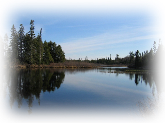
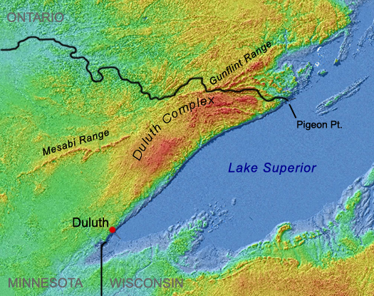
The proposed NorthMet mine project would be located in the St. Louis River watershed on the eastern edge of the Mesabi Iron Range, about 6 miles south of Babbitt and about 1 mile south of the existing iron-ore Northshore Mine. Processing of the ore would take place at a former industrial site, the LTV steel plant in Hoyt Lakes. Neither the proposed mine nor the processing facility is in the watershed containing the Boundary Waters Canoe Area Wilderness.
The total project area would include the open pit mine, a processing plant, tailings basin and an existing 7-mile-long railroad corridor for the transportation of ore between the mine and the processing plant.
PolyMet’s proposed project remains in the “environmental review” phase. This is the extensive process used to identify and analyze the potential environmental, social and economic impacts of the proposed project. Public input on the SDEIS is an important component of this phase.
Environmental review is not the approval phase of the project, which occurs during the permitting process.
At the state level, if the DNR determines the EIS is adequate, the next phase – the permitting process – would evaluate if the project can comply with all applicable environmental regulations and would set out the required measures that would need to be taken to avoid, minimize or mitigate impacts and provide the required financial assurance. The permitting phase also involves opportunities for public review of draft permits.
Similar to the state, the USFS issues a record of decision that completes its environmental review, and is followed by permitting and implementation. Unlike the other two co-leads, the USACE issues a record of decision that both completes its environmental review and renders its permit decision. For PolyMet’s proposal, this involves wetlands permitting for the USACE, while the USFS is focused on the proposed land exchange transaction process.
How to comment on the SDEIS
Public comments on the SDEIS can be submitted electronically at NorthMetSDEIS.dnr@state.mn.us or by mail to:
Lisa Fay, EIS Project Manager
MDNR Division of Ecological and Water Resources
Environmental Review Unit
500 Lafayette Road, Box 25
St. Paul, MN 55155-4025
During the 90-day comment period, the co-lead agencies will hold public information and input meetings in Duluth, Aurora and St. Paul where the public can comment in person. The meetings are listed below.
Thursday, Jan. 16, 2014
DECC – Duluth Entertainment Convention Center
350 Harbor Drive, Duluth, MN 55802
5 p.m. – open house
6:45-10 p.m. formal presentation and public comment period
Wednesday, Jan. 22, 2014
Mesabi East High School
601 1st St W, Aurora, MN 55705
5 p.m. – open house
6:45-10 p.m. formal presentation and public comment period
Tuesday, Jan. 28, 2014
Saint Paul RiverCentre
175 West Kellogg Blvd, Saint Paul, MN 55102
5 p.m. – open house
6:45-10 p.m. formal presentation and public comment period
In the event of a weather-related postponement of one or more of the public meetings, the DNR will make a public announcement.
The public meetings, co-hosted by DNR, USACE and USFS, will include informational stations and representatives from state and federal agencies. At the public meetings, participants can submit comments in writing, present them verbally or have their oral comments transcribed by a stenographer.
Public review copies of the SDEIS are available at the following locations: the DNR/MPCA Library, 520 Lafayette Road, St. Paul; the DNR Regional Office at 1201 East Highway 2, Grand Rapids; the DNR-Division of Lands and Minerals Regional Office at 1525 Third Avenue East, Hibbing; the Hoyt Lakes Public Library at 206 Kennedy Memorial Drive, Hoyt Lakes; the Babbitt Public Library at 71 South Drive, Babbitt; the Duluth Public Library, 520 West Superior Street, Duluth; and the Minneapolis Public Library, 300 Nicollet Mall, Minneapolis.
All written comments become a part of the Final EIS record and are public information. Written comments will be accepted until 4:30 p.m. on March 13, 2014.
Following the public comment period, the DNR and co-lead agencies will review all comments, respond to substantive comments, adjust the SDEIS if needed, and ultimately publish a Final EIS for public review.